
How to Add a Clickable World Map to WordPress
By: Botrous Kerolos
Published on:
If your organization works in more than one country, sooner or later someone asks for “a world map where people can click their country.” It might lead to a local office, a distributor, a shipping page, or a country guide.
This guide is for the person who has to build that map on a WordPress site. You do not need to write code. By the end you will know whether you need a map of countries or of continents, and you will have installed a WordPress world map plugin, colored and linked the areas that matter, added short tooltips, placed the map with a block, an Elementor widget, or a shortcode, and checked how it behaves on a phone.
The steps use the free world maps from WP Map Plugins, the tools I know best. The planning advice works with any clickable world map.
On this page
- Countries or continents? Choose the map that matches the job
- What you can do with a clickable world map
- Install the plugin and place the map
- Color the countries and group related areas
- Add links, tooltips, and, if needed, a legend
- Keep the map readable on a phone
- Worked example: a distributor map for 12 countries
- When a single-continent or country map is a better fit
- Common mistakes
- FAQ
Countries or continents? Choose the map that matches the job
Before you install anything, decide what a visitor should be able to click. Getting this wrong is the most common reason a world map gets rebuilt.
There are two kinds of clickable world map:
- A world map by countries. Every country is its own clickable area. In the WP Map Plugins version, that is 204 countries, each with its own color, link, and tooltip.
- A world map by continents. The world is divided into six large areas: Africa, Asia, Europe, North America, Oceania, and South America. A visitor can click a continent, not a country inside it.
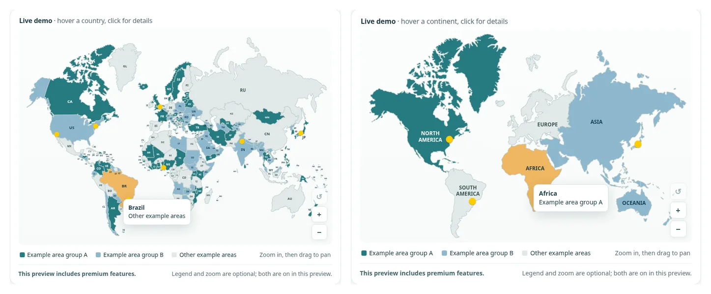
A continents map is quicker to set up, with only six areas to edit. A countries map takes longer, but it is the right choice if you have pages for individual countries.
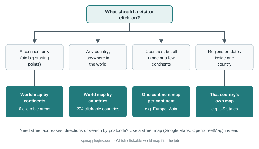
One more check: if visitors need street addresses, directions, or a postcode search, a street map such as Google Maps or OpenStreetMap is the better tool. A clickable world map answers “which country?”
What you can do with a clickable world map
Most world maps on WordPress sites do one of these jobs:
- Offices and local sites. Each country with an office or local-language site links to it.
- Distributors and partners. Colors show who covers each country; a click opens their contact page.
- Shipping and availability. Colors show where you ship and where you do not deliver yet.
- Projects. NGOs and agencies show where they have worked, one page per country.
- Teaching. Geography and history sites use the map as a menu into country or continent lessons. The post on using interactive world maps for educational sites covers that use in depth.
Install the plugin and place the map
The world map by countries and the world map by continents are separate plugins, so install the one you chose in the first section. They work the same way.
Step 1: Download and install
- Open the product page for your map: the interactive world map by countries plugin or the world map by continents plugin. Choose Download the free version to get the zip file.
- In WordPress, go to Plugins → Add New Plugin → Upload Plugin.
- Choose the zip file, click Install Now, then Activate.
A new item appears in the WordPress admin menu, such as World Map by Countries. Version 3.1.4 needs WordPress 6.3 or later and PHP 7.4 or later. The documentation covers the same steps in more detail.
Step 2: Open the editor
Click the map's name in the admin menu. You will see a live preview, which behaves like the published map, and a side panel with a searchable list of areas. With 204 countries, type a few letters (“Ger,” “Jap”) to find one. You can also select several countries and change them together.
Step 3: Place the map on a page
When the map is ready (we publish it later in this guide), place it with whichever method fits your site:
- Gutenberg block. In the block editor, add a block and search for the map's name.
- Elementor widget. Drag the map widget into a section or column.
- Shortcode. Paste
[wpmp-world-countries-map]for the countries map or[wpmp-world-continents-map]for the continents map. It works in the classic editor, widget areas, and most page builders. If shortcodes are new to you, the beginner's guide to shortcodes explains them.
All three show the same map, and published changes appear everywhere it is placed.
Color the countries and group related areas
Pick a small number of color groups
Two or three groups are usually enough: for example “has an office,” “served by partners,” and “everything else.” Each extra color is one more thing to decode.
For each group, write down one fill color as a hex code (such as #227A7C) and a slightly darker or lighter hover color. Keep enough contrast between the country color and its label so the two-letter labels stay readable.
Set the colors in the editor
- Search for the first country in the list and select it.
- Set its Color, Hover color, Label color, and Label hover color.
- Repeat for the other countries in the group, or select them all at once and set the colors together.
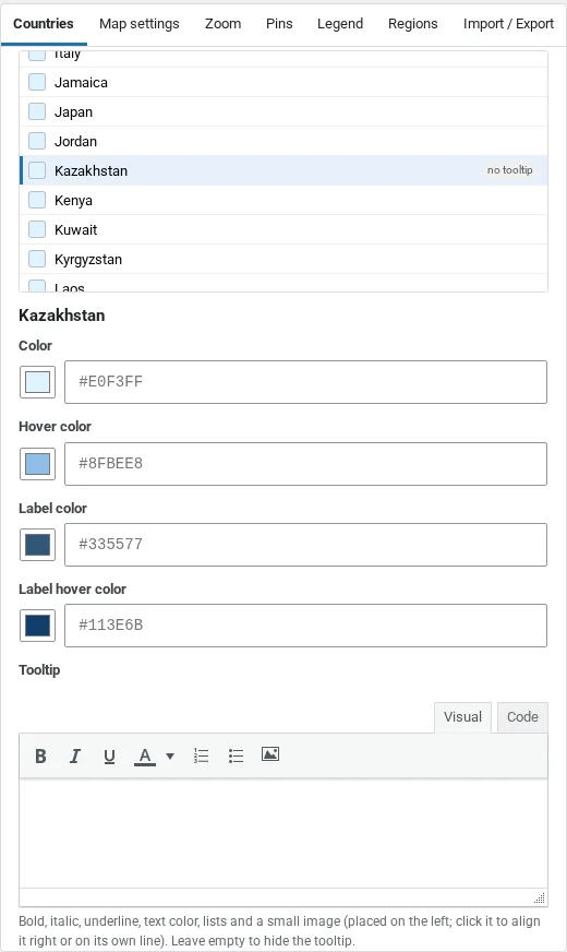
Countries you do not set keep the map-wide Inactive color from Map settings. A neutral inactive color keeps the countries you cover in focus.
Grouping countries (premium)
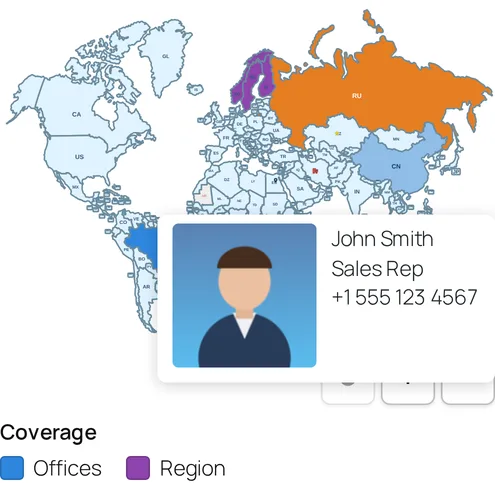
Premium adds Regions, which group countries so they highlight together and share one color, tooltip, and click action. That suits a “Nordic countries” page that covers several countries at once.
Add links, tooltips, and, if needed, a legend
Links
Under When clicked, choose Open a link and paste the page address, or Nothing for countries that only show a tooltip. For pages on your own site, opening in the same tab is usually best.
Only link a country to a page that exists and is genuinely about that country. If you have nothing to say about it yet, leave it unlinked.
Tooltips
A tooltip is the small label that appears on hover. Keep it short: the country name and a few words, such as “Germany · local distributor.” In the free version a tooltip is one line of plain text. Premium adds formatted tooltips with bold text, colors, lists, and a small image.
One limit: a tooltip cannot contain a clickable link, because it closes when the pointer leaves or the country is clicked. Link the country itself, or use a premium popup for text, images, links, and video.
Legend (premium, optional)
If your colors mean something, say what. Premium has an optional legend under the map. Without it, add one sentence under the map, such as “Teal: local distributor. Blue: export team.”
Keep the map readable on a phone
On a phone, the whole planet shrinks to the width of the screen. Large countries stay easy to tap; small ones, such as Luxembourg or Singapore, become tiny targets.
- Check the tap behavior. Phones have no hover. In Map settings, the On phones and tablets option lets you choose between “First tap shows the tooltip, second tap opens” and “One tap opens the link or popup.” Countries without a tooltip always open on the first tap.
- Put a text list under the map. For small countries and screen-reader users, a short list of the same links is the most reliable fallback. The post on creating an accessible web map explains why.
- Consider zoom. Premium adds optional zoom and pan controls, which make small countries easier to reach.
- Test on a real phone. Tap three or four countries and check each one does what you expect.
Because the map is inline SVG on your own page, it scales cleanly to any width without blurring. If you want the background on why that matters, see vector (SVG) vs raster (PNG) maps.
Worked example: a distributor map for 12 countries
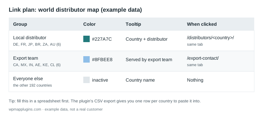
Here is a plan you can copy (example data, not a real company). A manufacturer has local distributors in six countries (Germany, France, Japan, Brazil, South Africa, and Australia) and an export team that serves six more (Canada, Mexico, India, the United Arab Emirates, Kenya, and Chile). Everywhere else, buyers use a general contact form.
Build it in five steps
- Pick the map. Visitors choose a country, and the countries are spread over six continents, so this is a job for the world map by countries.
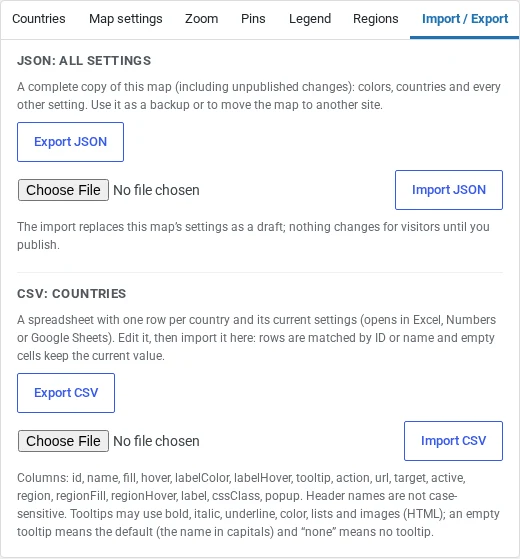
- Fill in a spreadsheet first. In the editor, open Import / Export and click Export CSV. You get one row per country, identified by its two-letter code (DE, FR, JP, and so on). For the 12 countries, fill in the
fill,hover,tooltip,action(uselink), andurlcolumns, and leave the other rows alone. - Import it. Click Import CSV and choose your file. Empty cells keep their current values, so the other 192 countries are untouched. The import is saved as a draft until you publish.
- Check in the preview. Hover over each colored country. Make sure the tooltip reads well and the link goes to the right page.
- Publish and place. Click Publish, then add the block or the
[wpmp-world-countries-map]shortcode to your distributors page, with a sentence under the map that explains the two colors.
The next time a distributor changes, you edit one row.
When a single-continent or country map is a better fit
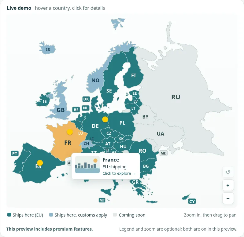
- All your countries are in one continent. If you only work in Europe, a Europe map shows the same countries much larger and easier to click.
- You work in several continents, but by region. Some sites have a page per continent and want country-level detail on each. The 6 continent maps package is six separate plugins (Africa, Asia, Europe, North America, Oceania, and South America), each edited and placed on its own. It is different from the world map by continents, which is a single map with six areas.
- Everything is inside one country. Use that country's map, such as the US map with its 50 states plus DC. The earlier guide on adding a clickable US map to WordPress walks through that case.
Common mistakes
- Buying the continents map when you need countries. The world map by continents has six clickable areas. If your pages are per country, you need the world map by countries. Check this first.
- Linking countries to pages that do not exist yet. Link what is ready; leave the rest neutral.
- Putting links in tooltips. Tooltips close on click, so links inside them cannot be used. Link the country, or use a premium popup.
- No text around the map. A heading and a sentence about what the map shows help search engines and screen-reader users.
FAQ
What is the difference between the world map by countries and the world map by continents?
They are two separate plugins. The world map by countries has 204 clickable countries, each with its own color, link, and tooltip. The world map by continents has six clickable areas, one per continent, and visitors cannot select individual countries on it. Choose by what a visitor needs to click.
Is the free world map a trial?
No. The free version is a complete map with the visual editor, colors and links for every area, one-line tooltips, the block, the Elementor widget, the shortcode, and JSON and CSV import and export. It shows a small credit link under the map.
Can a tooltip contain a link?
No. A tooltip closes when the pointer leaves the area or when the area is clicked, so nothing inside it can be clicked. Link the country itself, or use a premium popup window, which can hold text, images, links, and video.
Can I show more than one world map on my site?
Yes, in premium. Extra maps use their own shortcodes, such as [wpmp-world-countries-map-2], and each one has its own settings. The free version has one map.
How much does the premium version cost?
As of 20 November 2026, the premium world map by countries is a one-time payment of $29.95 and the premium world map by continents is $9.95. The package of six separate continent maps is $49.95. There is no subscription and no license key. Check the product page for the current price.
What happens to my map if I upgrade from free to premium?
You install and activate the premium plugin. It replaces the free copy and keeps your map settings, so you do not have to redo your colors, links, or tooltips.
Try it on your own site
If you have pages for individual countries, start with the free version of the World Map by Countries and build the map from a spreadsheet as in the example above. If your content is organized by continent, the free World Map by Continents is the quicker route. Each product page has the free download, a live demo, and a free-vs-premium comparison.
WP Map Plugins is our product.
Related reading
- How to Add a Clickable US Map to WordPress (Step by Step)
- Mapping History: Using Interactive World Maps for Educational Sites
- Vector (SVG) vs. Raster (PNG) Maps: Which Is Best for Web Design?

About the Author
Botrous Kerolos has been designing and building interactive maps for the web since 2009 — from early Flash/SWF maps to modern SVG — and leads development at WP Map Plugins, helping WordPress sites turn static content into fast, accessible, interactive experiences.