We create interactive maps with love since 2009 | Reviews | Latest plugin update / test: April 2024

Interactive Map of Kansas

WordPress Plugin

  • Does NOT require JavaScript or PHP knowledge
  • Well Organized Interface
  • Responsive and Mobile Friendly
  • One-time purchase, No Annual Fees
  • Free Life Time Updates
  • Tech Support Experts
Allen Anderson Atchison Barber Barton Bourbon Brown Butler Chase Chautauqua Cherokee Cheyenne Clark Clay Cloud Coffey Comanche Cowley Crawford Decatur Dickinson Doniphan Douglas Edwards Elk Ellis Ellsworth Finney Ford Franklin Geary Gove Graham Grant Gray Greeley Greenwood Hamilton Harper Harvey Haskell Hodgeman Jackson Jefferson Jewell Johnson Kearny Kingman Kiowa Labette Lane Leavenworth Lincoln Linn Logan Lyon Marion Marshall McPherson Meade Miami Mitchell Montgomery Morris Morton Nemaha Neosho Ness Norton Osage Osborne Ottawa Pawnee Phillips Pottawatomie Pratt Rawlins Reno Republic Rice Riley Rooks Rush Russell Saline Scott Sedgwick Seward Shawnee Sheridan Sherman Smith Stafford Stanton Stevens Sumner Thomas Trego Wabaunsee Wallace Washington Wichita Wilson Woodson Wyandotte * County names can be set as hidden like this example.

Interactive Map of Kansas - WordPress Plugin

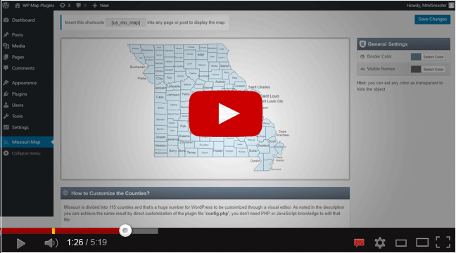
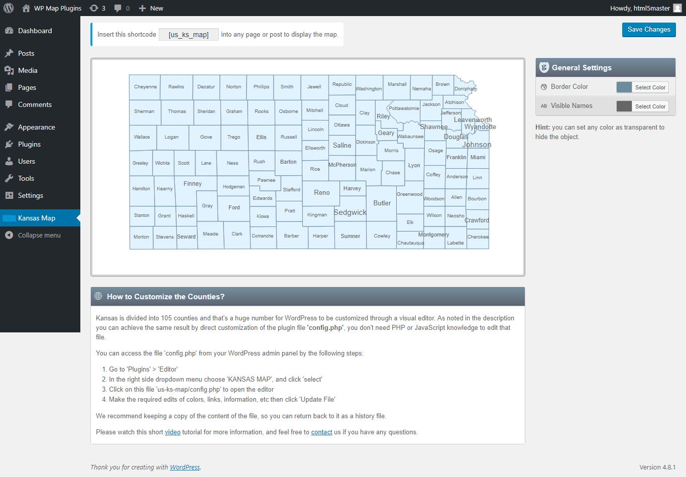
The interactive map of Kansas WordPress plugin gives you an easy way to install and customize a professional looking interactive map of Kansas with 105 clickable counties, then insert the shortcode in any page or post to display the map on your WordPress website.

Main Features

  • One-time purchase, no annual or subscription fees.
  • Well organized interface, easy to use admin panel (but No visual editor).
  • You can use the map shortcode in as many pages as you want to display the map.
  • Install up to 3 instances of the plugin (included) to create 3 different maps with different colors, links, etc.
  • New! Easily integrated with 3rd party popup plugins (tested with Popup Maker *free*), so you can open a modal window for each county. Watch this short Youtube Video.
  • Responsive and fully resizable.
  • Works perfectly on desktops along with smartphones.
  • Small file size > Fast loading > SEO friendly.

List of the clickable counties in the map of Kansas

Each county can be customized independently (colors, link, hover information, etc).

  1. Allen
  2. Anderson
  3. Atchison
  4. Barber
  5. Barton
  6. Bourbon
  7. Brown
  8. Butler
  9. Chase
  10. Chautauqua
  11. Cherokee
  12. Cheyenne
  13. Clark
  14. Clay
  15. Cloud
  1. Coffey
  2. Comanche
  3. Cowley
  4. Crawford
  5. Decatur
  6. Dickinson
  7. Doniphan
  8. Douglas
  9. Edwards
  10. Elk
  11. Ellis
  12. Ellsworth
  13. Finney
  14. Ford
  15. Franklin
  1. Geary
  2. Gove
  3. Graham
  4. Grant
  5. Gray
  6. Greeley
  7. Greenwood
  8. Hamilton
  9. Harper
  10. Harvey
  11. Haskell
  12. Hodgeman
  13. Jackson
  14. Jefferson
  15. Jewell
  1. Johnson
  2. Kearny
  3. Kingman
  4. Kiowa
  5. Labette
  6. Lane
  7. Leavenworth
  8. Lincoln
  9. Linn
  10. Logan
  11. Lyon
  12. Marion
  13. Marshall
  14. McPherson
  15. Meade
  1. Miami
  2. Mitchell
  3. Montgomery
  4. Morris
  5. Morton
  6. Nemaha
  7. Neosho
  8. Ness
  9. Norton
  10. Osage
  11. Osborne
  12. Ottawa
  13. Pawnee
  14. Phillips
  15. Pottawatomie
  1. Pratt
  2. Rawlins
  3. Reno
  4. Republic
  5. Rice
  6. Riley
  7. Rooks
  8. Rush
  9. Russell
  10. Saline
  11. Scott
  12. Sedgwick
  13. Seward
  14. Shawnee
  15. Sheridan
  1. Sherman
  2. Smith
  3. Stafford
  4. Stanton
  5. Stevens
  6. Sumner
  7. Thomas
  8. Trego
  9. Wabaunsee
  10. Wallace
  11. Washington
  12. Wichita
  13. Wilson
  14. Woodson
  15. Wyandotte

Kansas is divided into 105 counties and that's a huge number for WordPress to be customized through a visual editor. So this map doesn't have a Visual Editor but can be customized by editing a simple plugin file, please watch this short video tutorial for more information, and feel free to contact us if you have any questions.


Customer Reviews

What a great, user-friendly map! Does everything I need and looks beautiful. Customer support is awesome, the developer is kind and helpful. Highly recommend this plugin!

Athascg

If you need a flexible map plugin with the BEST support available AND for as inexpensive as it is, you want this Interactive Map plugin. Hands down the best service and communication I've ever had with a developer of products I've purchased. I never expected the service I got. Buy this plugin, you will NOT be disappointed.

kpukylo


Frequently Asked Questions

Yes, you can write any text and add images.

Yes, it’s SVG based (Not Flash) and it's responsive and fully resizable, it works perfectly on desktop along with mobile devices smartphone.

Yes, starting from the plugin version V2.4 you can use more than one map in the same page.

Yes, you can install up to 3 instances of the plugin to create 2nd and 3rd maps (included).

Yes, simply change its 'enable' value from true to false.

Yes, also you can choose to open it in the same window or in a new window or open a modal window with the help of the Popup Maker plugin (watch video).

Yes, we offer customization service for extra cost, please contact us for more details.

Plugin Version: 2.7
Tested up to: WP 6.5.2
Tested on: ✓✓

Watch a short video - How it works?
How it works? Map WordPress Plugin
You may be interested in:
Interactive US Map WordPress Plugin
Do you need other state maps?
50 Individual US State Maps
Screenshot
Interactive Map of Kansas WordPress Plugin

CONTACT US

We are happy to help :)

If you need support or have any question:

Home | Contact Us | Terms | Privacy Policy | Site Map
COPYRIGHT © All rights reserved to WPMapPlugins.com